Whoa, that’s one big tree … check it out in a new Street View collection
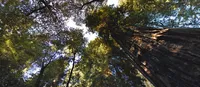
Today, Google Maps is bringing you more Golden State beauty—we’ve added six destinations to our California State Parks Street View collection. In the Big Basin Redwoods State Park, you can gaze up at California’s famous redwoods, take in the spectacular scenery, and learn about the history of the park. Check out these Street View snapshots, as well as behind-the-scenes photos of the Sempervirens Fund using the Trekker and 360-degree cameras to collect this imagery.
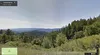
Frolic in the meadows, gaze up at the trees, or check out some cool rock formations. Castle Rock State Park has something for every explorer.

There’s not a light at the end of the tunnel, there’s a beach at the end of the hike. The 31-mile Waddell Beach Skyline to the Sea Trail starts in the Santa Cruz Mountains and ends at Waddell State Beach.
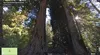
This 2,000-year-old Redwood tree is dubbed "Father of the Forest."

At this site on May 15, 1900, A.P. Hill and a group of others formed the Sempervirens Club. Their mission was to protect the coast redwoods, and they later created Big Basin Redwoods State Park. The club went on to protect more than 34,000 acres of redwood forest in the Santa Cruz Mountains.

Berry Creek Falls is located in an especially lush section of Big Basin Redwoods State Park. The area’s diverse habitat is comprised of coastal marsh, Monterey pine forest, oak woodland, riparian woodland, and, of course, redwood forest.

A Sempervirens Fund volunteer maps the Sequoia Trail in Big Basin Redwoods State Park (photo courtesy of Sempervirens Fund).

This Sempervirens Fund volunteer is on top of the world! (Photo courtesy of Sempervirens Fund.)


