New ways maps and AI keep communities safe and informed
With Google’s AI technology and mapping information, people and organizations all over the world can access helpful, reliable information needed to make progress toward tackling global challenges like climate change. At Search On today, we’re sharing new mapping features that help keep communities safer, more sustainable, and discoverable — no matter where they are in the world.
Introducing the wildfire layer on Google Maps
With climate change, wildfires are growing increasingly more common in many parts of the world. Last year, we launched a wildfire boundary map powered by satellite data to help people in the U.S. easily understand the approximate size and location of a fire — right from their device.
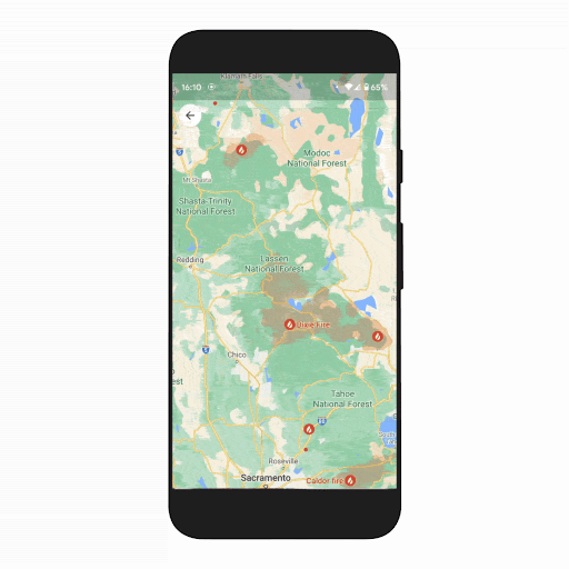
Building on this, we’re now bringing all of Google’s wildfire information together and launching it globally with a new layer on Google Maps. With the wildfire layer, you can get up-to-date details about multiple fires at once, allowing you to make quick, informed decisions during times of emergency. Just tap on a fire to see available links to resources from local governments, such as emergency websites, phone numbers for help and information, and evacuation details. When available, you can also see important details about the fire, such as its containment, how many acres have burned, and when all this information was last reported.
The wildfires layer will start to roll out globally this week on Android, with iOS and desktop coming in October, and will display most major fires that cause significant evacuations. In the U.S., the layer will expand to include more fires thanks to data from the National Interagency Fire Center (NIFC). We plan to expand this level of detail to more countries, starting with Australia, in the coming months.
See critical, up-to-date information with the new wildfire layer on Google Maps
Tree Canopy Insights expands to 100 new cities
Cities around the world have told us that it can be difficult to set concrete climate action goals when they don’t have access to reliable, trusted information. That’s why in 2022, we’ll expand the Environmental Insights Explorer (EIE) Tree Canopy tool from 15 U.S. cities to over 100 new cities around the globe in places like Guadalajara, London, Sydney and Toronto.
Our Tree Canopy Insights uses aerial imagery and advanced AI capabilities to identify places in a city that are at the greatest risk of experiencing rapidly rising temperatures. These places, known as heat islands, disproportionately impact lower-income communities and contribute to a number of public health concerns — from poor air quality to dehydration. With Tree Canopy data, local governments have free access to insights about where to plant trees to increase shade, reduce heat and mitigate these adverse effects.
First piloted in Los Angeles, Tree Canopy data has become a critical piece of the city’s long-term goal to increase tree shade by at least 50% by 2028. Learn more about how other local governments plan to use Tree Canopy Lab data this year.
Tree Canopy Coverage in Los Angeles

Assigning addresses at scale with the new Address Maker app
In addition to helping cities with environmental initiatives, we’re helping governments and NGOs provide addresses to people and businesses around the world. Several billion people still don’t have an address, making it difficult to do things many people take for granted, like voting, opening a bank account, applying for a job, or simply getting a package delivered. With our new free Address Maker app, these organizations can now use our open-source system called Plus Codes to create unique, functioning addresses at scale, right from an Android app.
Creating Plus Code addresses using Address Maker

Previously, creating addresses for an entire town or village could take years.Address Maker shortens this time to as little as a few weeks — helping under-addressed communities get on the map quickly, while also reducing costs. Address Maker allows organizations to easily assign addresses and add missing roads, all while making sure they work seamlessly in Google Maps and Maps APIs. Governments and NGOs in The Gambia, Kenya, India, South Africa and the U.S. are already using Address Maker, with more partners on the way. If you’re part of a local government or NGO and think Address Maker could help your community, reach out to us here g.co/maps/addressmaker.
Giving people access to useful, actionable information that can drive change is core to Google. To learn about more ways we’re using technology to help people solve problems, see what else we announced at Search On.


