How technology can help us become more sustainable
We want to create technology that helps millions of others understand our changing world and live more sustainably—whether it’s connecting people with public transit routes, or using the data that powers Google Earth to help you see if your roof is good for solar panels. In honor of Earth Day this month, we’ve gathered together some of the ways Google can help you reduce your everyday emissions and learn more about preserving our world.
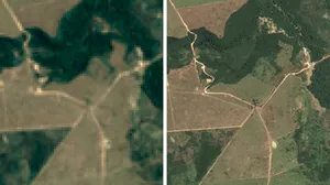
Monitoring forests and wildlife
Google Earth satellite technology gives scientists and environmentalists a way to measure and visualize changes of the world on both land and water. This technology can have great impact on monitoring endangered animal populations around the world. For example, with the help of Global Forest Watch, powered by Google Earth Engine, scientists at the University of Minnesota are suggesting that wild tiger populations may rebound by 2022, due to the efforts to restore tiger habitats in key regions.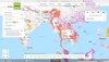
Going solar
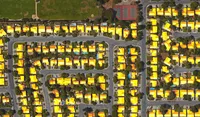
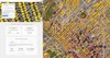
Looking to generate clean energy savings with solar power on your home? Check out Project Sunroof, a solar calculator that estimates the impact and potential savings of installing solar on the roof of your home. Taking Google Earth imagery and overlaying annual sun exposure and weather patterns, Sunroof is able to assess viable roof space for solar panel installation, estimate the value of solar and savings based on local energy costs, and connect you with providers of solar panels in your area.As of this week, Sunroof expanded to 42 states across the U.S. (from 10 states in December), which makes imagery and data available for a solar analysis to 43 million rooftops. We’re also working with organizations like Sierra Club and their Ready for 100 campaign to help analyze the solar potential of cities across the US.
Project Sunroof shows you the solar potential of your home and city, allowing you to realize its renewable potential. The image on the right shows how much sunshine Denver, CO residents can capture with solar.
Measuring air pollutants
For the past few years, Google Earth Outreach and the Environmental Defense Fund (EDF) have been working together to map methane leaks from natural gas pipelines under our streets. Since methane is a very potent greenhouse gas (GHG), even small leaks can add up to big emissions that can hurt our climate. By attaching methane analyzers to select Street View cars, we’ve driven more than 7,500 miles and have mapped 4,200+ leaks in 10 cities. What we found ranges from an average of one leak per mile (in Boston) to one leak every 200 miles (in Indianapolis), demonstrating the effectiveness of techniques like using plastic piping instead of steel for pipeline construction. We hope utilities can use this data to prioritize the replacement of gas mains and service lines (like New Jersey’s PSE&G announced last fall). We’re also partnering with Aclima to measure many more pollutants with Street View cars in California communities through this year. Anyone can explore the maps at www.edf.org/methanemaps.Technology is crucial to increasing energy efficiency, raising climate change awareness, and sustainability efforts. To learn more about what you can do to help, take a moment to explore our Google Earth Outreach site, where these tools and more are described in depth.